Heavy rain is set to hit Sydney this afternoon and intensify overnight, with flood warnings in place.
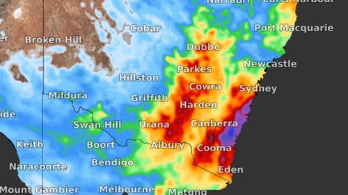
But it's not just the capital in the firing line, with the Bureau of Meteorology (BoM) warning between 100 and 250mm of rain was predicted to batter the state from the Hunter region to the Far South Coast.
A flood watch for a number of the state's rivers and catchments will be issued due to the risk of flash flooding.
"The focus is on coastal NSW from the Hunter to the South Coast," NSW State Emergency Service Assistant Commissioner Dean Storey said.
The Bureau of Meteorology late on Tuesday warned heavy rainfall, possibly leading to flash flooding, was forecast from Wednesday afternoon about the Illawarra and parts of the South Coast and Southern Tablelands.
The heavy rain is expected to extend Metropolitan and parts of the Central Tablelands and Hunter districts on Thursday.
Weather bureau meteorologist Ailsa Schofield said the heaviest rainfall was expected on Thursday.
"On Wednesday we might see rainfall total in excess of 100mm," Ms Schofield said.
"On Thursday we might see rainfall totals in excess of 200-250mm.
"On Friday we will see higher rainfall totals in excess of 150mm."

Ms Schofield warned moderate flooding could occur in the Upper Hunter, Hawkesbury and Nepean valley, as well as the Colo River.
She also said minor flooding could occur in the Illawarra, South Coast and Far South Coast.
"The catchments are very wet it won't take much rainfall to see flash flooding," she said.
Meanwhile, rain is also predicted in the already flood-ravaged north of NSW where recovery efforts after two flooding events in less than a month caused extensive damage to the region.
"There remains the risk of some rainfall impacting the North Coast and Northern Rivers areas which have seen so much rainfall in recent times," Assistant Commissioner Storey said.
Not only is heavy rainfall predicted, but more damaging winds and large waves will pummel the NSW coast.
"This surge of wind and swell are being caused by a tropical cyclone moving south across the Coral Sea and pressing against a high pressure system in the southern Tasman Sea," Weatherzone meteorologist Ben Domensino said.
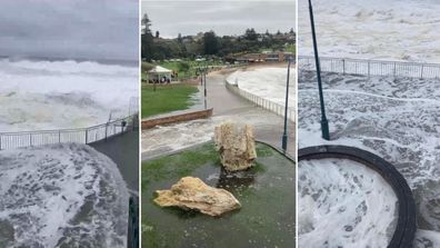
Massive five-metre waves batter Sydney's beaches
Waves could reach highs of up to two to three metres later this week and NSW coastal residents are warned of the risk of erosion.
"While this swell will be smaller than the waves that inundated the state's coast last weekend, they may still cause erosion in some areas," Mr Domensino said.
Thunderstorm warning for Queensland
Rain and thunderstorms are also expected to develop over southern Queensland between tomorrow and the weekend.
"Rain and thunderstorms will linger over parts of eastern and south-eastern Australia into the weekend, and some of these storms could also become severe," Mr Domensino said.
Some of the rain in Queensland has been brought by Tropical Cyclone Fili near New Caledonia.
The cyclone is forecast to drift south but will remain "well offshore" the coast of Queensland, BoM meteorologist Helen Reid said.
Queensland's coast will also experience hazardous surf.
"Swells are expected to be an easterly three-metre with long period, generated by a combination of Tropical Cyclone Fili and a high moving into the Tasman Sea," Ms Reid said.
Some flood warnings also remain in place in southern Queensland, including the Condamine catchment, but the forecast rain could cause more flooding later this week.
https://news.google.com/__i/rss/rd/articles/CBMisAFodHRwczovL3d3dy45bmV3cy5jb20uYXUvbmF0aW9uYWwvd2VhdGhlci1uZXdzLWhlYXZ5LXJhaW4tcHJlZGljdGVkLWZvci1uZXctc291dGgtd2FsZXMtZWFzdC1jb2FzdC10aHVuZGVyc3Rvcm1zLWluLXF1ZWVuc2xhbmQtYW5kLXZpY3RvcmlhLzU4NGUwMWI3LTU2ZmQtNDFlNS1hOTM5LTYyYTRlMzY5Y2NlY9IBRWh0dHBzOi8vYW1wLjluZXdzLmNvbS5hdS9hcnRpY2xlLzU4NGUwMWI3LTU2ZmQtNDFlNS1hOTM5LTYyYTRlMzY5Y2NlYw?oc=5
2022-04-05 20:10:54Z
1360924535
Bagikan Berita Ini


0 Response to "Falls of up to 500mm predicted for NSW 'rain bomb' this week - 9News"
Post a Comment