Key posts
Concern moves to inland NSW
NSW SES Commissioner Carlene York says while Sydney’s forecast is “pretty good today”, there are increasing concerns for a number of places in the state.
“Just because the sun comes out, doesn’t mean the rivers aren’t changing for us and increasing in height,” Ms York told 2GB.
While concerns remain for the Hawkesbury-Nepean River areas, the SES’ focus will move towards Moree, Tamworth, Grafton and some parts of Port Macquarie.
The Colo community in the Central Tablelands was issued with an evacuation order on Tuesday, but the waters did not rise as much as expected. However, Ms York said the danger has not passed for the area.
“We are still concerned about that area today... the weather will be better today so we will be able to get the helicopters if any people in that area are concerned about their safety,” she said.
“The waters will slowly start to recede... some roads will start to be passable and I just warn people about potholes and damage to the roads and it can be quite dangerous so just be careful.”
Clearer weather for parts of state
The Bureau of Meteorology forecaster Helen Kirkup said while parts of the state will not experience significant rains on Wednesday, there were still several flood warnings for some locations.
Sydneysiders will welcome clear skies, with a top of 30 degrees and a 5 per cent chance of rain. But some areas to the west of the city, including along the Nepean and Hawkesbury River catchments, are still on high alert for flood warnings.
Overnight an evacuation warning has been issued for the lower reaches along the Hawkesbury River from Wisemans Ferry to Brooklyn. Residents in this area should prepare to evacuate.
Ms Kirkup said one of the areas of greatest concern is the Gwydir River in Moree, in the state’s north, where a renewed weather warning this morning is likely.
“It’s a pretty clear week for most places,” she said.
The South Coast, which was issued a severe weather warning on Tuesday which has since been cancelled, may see some rain tomorrow.
“The South Coast might still get some [rain], but we’re not talking about the numbers we have been over the past few days - we’re are talking about 5mm to10mm.”
Photographs of blue skies
After almost a week of heavy rains, parts of the state have begun to see some blue skies. The Sydney Morning Herald’s photographer Wolter Peeters captured these images of a blue sky over the Grose Valley from the upper Blue Mountains on Tuesday.
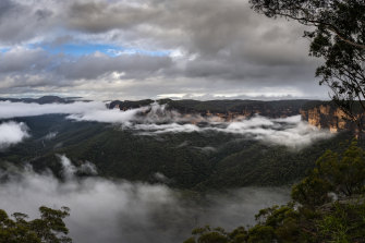
A glimpse of blue over the Grose Valley on Tuesday. Credit:Wolter Peeters
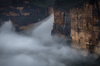
The Blue Mountains in NSW on Tuesday.Credit:Wolter Peeters
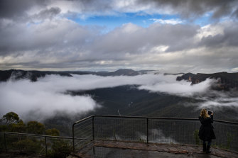
A glimpse of blue sky. Credit:Wolter Peeters
Before and after satellite imagery shows early impact of NSW floods
By Ben Grubb
The areas around Port Macquarie and Taree, where the Hastings and Manning Rivers respectively run through, have been the focus of much of the devastation on the Mid North Coast over the past few days as a result of flooding.
Using satellite imagery, the Herald is able to give a bird’s-eye view of the spread of the inundation by comparing the regions between early March and March 19.
Port Macquarie
Satellite imagery of Sydney’s west and north-west has not yet become available in a way that is easy to compare the areas before and after flooding, especially since flooding in those areas started to occur later than in the state’s north.
Evacuation warning issued for Hawkesbury River
By Laura Chung
An evacuation warning has been issued for the lower reaches along the Hawkesbury River from Wisemans Ferry to Brooklyn.
Residents in this area should prepare to evacuate.
Those who are unable to evacuate may become isolated over the coming days as river levels continue to rise, the SES warns.
Residents in the lower reaches should prepare to leave as early as possible.
Plan to:
- Take pets, essential items, warm clothes, medicines, insurance documents and valuables with you.
- Take drinking water and food due to expected travel time.
Looking back at the Sydney radar in one week
It’s hard to believe the rain over Sydney has eased after days of relentless falls.
Weatherzone developer Andrew Miskelly on Tuesday shared the following on social media, captioned: “Reflectivity from Sydney’s weather radar between last Wednesday and this afternoon”.
It shows the Terrey Hill’s radar in the seven days from March 17 to March 23.
162 schools closed across NSW
A total of 162 public schools are closed in NSW “due to localised flooding”.
The Department of Education confirmed the number of non-operational schools in an update at 6am on Wednesday.
“Local flooding and road closures are limiting access to some areas so it may take some days to fully assess any damage to some schools,” a spokesperson for the department said.
“We are continuing to work closely with emergency services to ensure our school communities remain safe and fully informed about any disruption to schooling this week.
“Before leaving home, parents and carers should consider their local situation including any existing road closures, transport disruptions and forecast weather conditions
You can check the full list here.
Good morning
Good morning and welcome to our live coverage of the NSW floods.
Here’s a summary of yesterday’s events:
- A number of evacuation orders were issued by the NSW SES including for the Colo River, people in low-lying properties in Moree and low-lying areas of Southgate, with up to 15,000 people on standby across the state.
- Notable rainfall totals to 9am on Tuesday include 150.4 millimetres at Caroda Hill, 150 millimetres at Moree, 132 millimetres at Chillingham, 130 millimetres at Gravesend and 126 millimetres at Limpinwood.
- Nearly 12,000 people had lodged insurance claims by Tuesday afternoon.
- The leader of a team of firefighters who rescued a family-of-six from their home near Port Macquarie said they had to pull snakes out of the life rafts being paddling back to safety.
- SES crew members making the 20-kilometre return boat trip from George Street at Windsor to Wilberforce on Tuesday afternoon said it would take weeks to fully assess the extent of the damage, as the Hawkesbury River peaked at 12.75 metres overnight.
- Blue skies appeared over Sydney as the Bureau of Meteorology cancelled its severe weather warning for the Metropolitan, Northern Rivers, Mid North Coast, Hunter, Illawarra, Central Tablelands, North West Slopes and Plains, South West Slopes, Australian Capital Territory and Northern Tablelands districts.
- The bureau said heavy rain, leading to flash flooding for areas of the South Coast and Snowy Mountains continued into the night but conditions would ease “as rain rates drop”.
Read more here
Most Viewed in National
https://news.google.com/__i/rss/rd/articles/CBMiqwFodHRwczovL3d3dy5zbWguY29tLmF1L25hdGlvbmFsL25zdy9uc3ctZmxvb2RzLWxpdmUtdXBkYXRlcy13aWxkLXdlYXRoZXItbW92ZXMtdG93YXJkcy1zb3V0aC1jb2FzdC1hcy1jbGVhcmVyLXNraWVzLWFwcGVhci1vdmVyLXN5ZG5leS1taWQtbm9ydGgtY29hc3QtMjAyMTAzMjMtcDU3ZGdjLmh0bWzSAasBaHR0cHM6Ly9hbXAuc21oLmNvbS5hdS9uYXRpb25hbC9uc3cvbnN3LWZsb29kcy1saXZlLXVwZGF0ZXMtd2lsZC13ZWF0aGVyLW1vdmVzLXRvd2FyZHMtc291dGgtY29hc3QtYXMtY2xlYXJlci1za2llcy1hcHBlYXItb3Zlci1zeWRuZXktbWlkLW5vcnRoLWNvYXN0LTIwMjEwMzIzLXA1N2RnYy5odG1s?oc=5
2021-03-23 20:41:29Z
52781443221396
Bagikan Berita Ini


0 Response to "NSW floods LIVE updates: Clearer skies appear over Sydney and Mid North Coast but flood risk continues - The Sydney Morning Herald"
Post a Comment