Hawkesbury residents are facing a tense morning, with flood levels predicted to exceed those of the 2021 disaster by midday.
Heavy rain has eased across much of Sydney but severe weather warnings remain in place as New South Wales braces for a day of dangerously high winds.
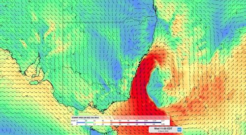
Wind gusts of 111 km/h were recorded at Molineux Point at 9.34pm, while shortly before that, gusts of 94 km/h were recorded at Sydney Airport around 9.20pm.
The damaging wind gusts are expected to persist through the day.
A separate severe weather warning for damaging and hazardous surf is currently in place for the Hunter Coast, Sydney Coast, Illawarra Coast, Batemans Coast and Eden Coast.
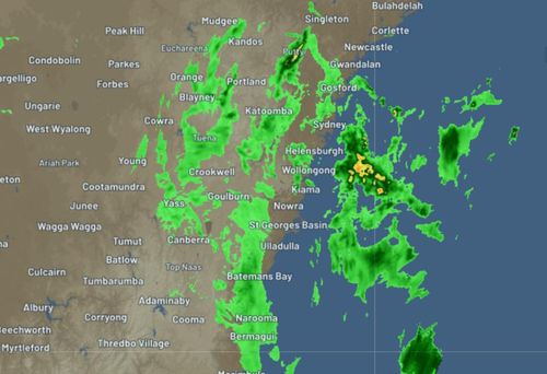
The Bureau expects areas which may be affected to include: Gosford, Maitland, Sydney, Penrith, Parramatta, Wollongong, Nowra, Bowral, Batemans Bay, and Goulburn.
The BoM says heavy rainfall is no longer expected on Wednesday and has been removed from the current warnings but the coastline copped a drenching on Tuesday night, with moderate falls showing on the radar.
The Bureau are forecasting major flooding at Windsor today, which will be above the levels seen in March last year and just below the March 1978 flood event.
"Rapid rises have been observed at Windsor where the river level has exceeded the March 2021 event and is likely to reach 14.30 metres around midday Wednesday, which is just below the March 1978 event (14.46 metres)," the BoM said in a warning issued just before midnight.
Major flooding above the levels seen last year is also taking place along the Hawkesbury River at North Richmond, Windsor, Sackville, Lower Portland and Wisemans Ferry.
"Forecast rainfall for Wednesday morning may cause further rises in the Hawkesbury Nepean Valley," they noted.
Communities in the region are already facing being cut off, with floodwaters isolating Mulgrave.
Major flooding is also occurring at Wallacia, with moderate flooding recorded at Menangle Bridge and Camden.
There's also been a moderate flood warning update for the St George's Basin are with Island Point Rd approaching a peak and the Sussex Inlet may peak at the moderate flood level, with evacuation orders in place for residents in both areas.
Earlier in the day, residents in Sydney's Northern Beaches were put on alert for possible evacuations after a massive downpour across the region.
Around 102mm of rain had fallen in the three hours to 2.30pm at Mona Vale Golf Club, while in nearby Forestville, 124mm of rain was recorded in the six hours to 11am.
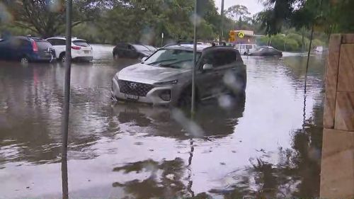
And Mosman copped 51mm of rain in the one hour to 1.45pm.
The deluge sparked evacuation warnings as Manly Dam threatened to spill and floodwaters began quickly rising in Freshwater, Brookvale, Curl Curl and the surrounding suburbs.
Vehicles were partially submerged and some roads in the area were cut off, while cars began floating on the Roseville Bridge.
The Northern Beaches is now facing a massive clean-up task, and while roads are open to local residents and business owners, other members of the public are urged to avoid the area.
https://news.google.com/__i/rss/rd/articles/CBMiiQFodHRwczovL3d3dy45bmV3cy5jb20uYXUvbmF0aW9uYWwvbnN3LXdlYXRoZXItdXBkYXRlLXNldmVyZS10aHVuZGVyc3Rvcm1zLXJhaW4tZmxvb2Rpbmctc2V2ZXJlLXdpbmRzLzI3NzE3ODI1LWVmZTAtNGMzMi1hNmE1LWI2NmNiMzg5MGQ3YdIBAA?oc=5
2022-03-08 19:00:08Z
1320175231
Bagikan Berita Ini


0 Response to "Hawkesbury bracing for 1978-level flood disaster - 9News"
Post a Comment