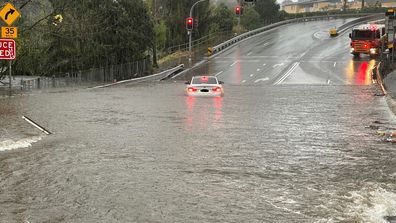
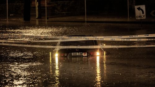
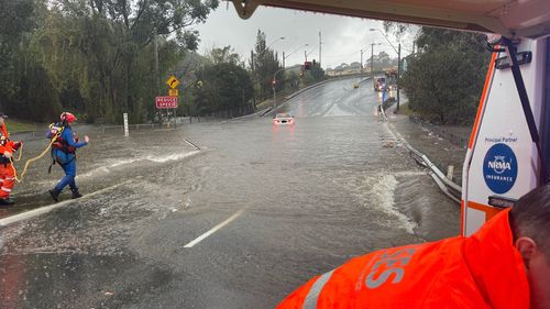
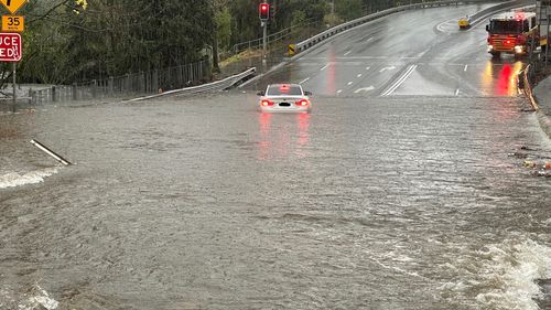
Thousands of people in low-lying areas across Sydney's south-west have been ordered to leave their homes or risk becoming isolated as floodwaters rise, with more heavy rain still to come.
Residents in parts of Camden, Woronora, Chipping Norton, Georges Hall, Lansvale, Moorebank and Warwick Farm are among those affected as an overnight deluge hit swollen waterways.
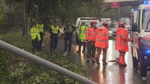
More than 1000 calls for help to the NSW State Emergency Service (SES) were made overnight, with dozens of rescues already made yesterday, including a woman in her 20s who was left clinging to a tree in floodwaters for more than an hour near the train station at Harris Creek in the Sydney suburb of Holsworthy.
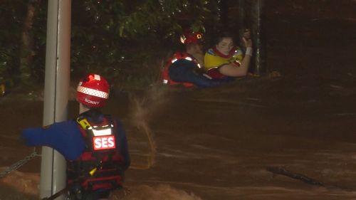
SES crews rescued the woman from the floodwaters and escorted her back to land by boat.
A number of evacuation orders have already been issued this morning, with the BoM warning the intense rainfall could bring six-hourly totals of up to 150mm over the next few days.
Residents in Camden were issued an order to evacuate by 7am in some areas or risk becoming trapped as the Camden Weir rises.
The order applied to Edward Street; Peter Avenue between Onslow Avenue and Belgenny Avenue; and properties near Matahill Creek on Barsden Street.
An earlier order also applied to properties near the river on Chellaston Street and those near Matahill Creek on Cawdor Road.
Pleasure Point was also issued with a warning for the area bounded by the railway to the east, the Georges River to the north-east and Heathcote Road to the south.
Residents were told "you may be trapped without power, water and other essential services and it may be too dangerous to rescue you".
Locals hit by fourth flood this year
Wallacia residents in the Bents Basin area in properties between Silverdale Road from Blaxlands Crossing Bridge to the beginning of the steeprise of the road and the Nepean River were also ordered to evacuate by 9am as the Wallacia Weir approached 9m.
Residents have been advised to stay with family, friends or at accommodation outside of flood areas.
An evacuation centre has been established at the Narellan Family and Community Centre at 20 Queen Street, Narellan.
A flood warning has also been issued for minor to major flooding along the Hawkesbury, Nepean and Colo rivers over the coming days.
Major flooding is also possible at Menangle and North Richmond from today.
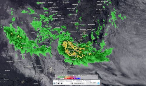
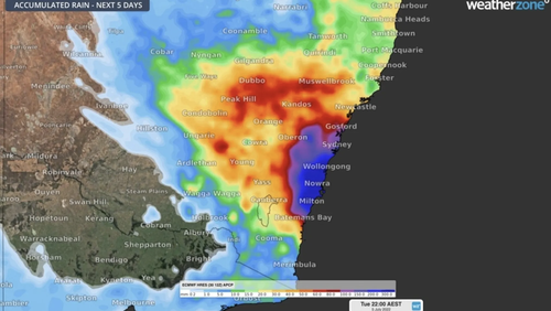
The forecast is for more heavy rainfall with the Bureau of Meteorology (BoM) saying an East Coast low is likely to develop during Sunday, lingering just offshore through Monday.
It will be accompanied by locally intense winds and large seas.
As a result, river levels - which began rising on Saturday - are expected to be most impacted today and through to Monday or Tuesday.
Severe weather warnings remain in place for Metropolitan, Illawarra and parts of Hunter, Central Tablelands and Southern Tablelands forecast districts.
The heavy rain is expected to extend beyond the Illawarra and far northern parts of the South Coast to the broader Sydney area, including the Blue Mountains.
The deluge has already seen some parts of the state get more than three times their average monthly rainfall within the first two days of July.
Shellharbour reported 3.2 times its average July rainfall in the 24hours to 9am Saturday, according to Weatherzone, recording a staggering 193mm in the gauges.
Albion Park (172mm, 3.1 times its monthly average), Beaumont (161mm, 1.6 times average), and Nowra (126mm, 1.9 times average) also recorded rain surpassing their July rainfall averages.
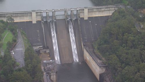
WaterNSW said Warragamba Dam storage spilled at 2am on Sunday, ahead of expectations, due to the intensity of rain over the catchment
At 7am the rate of spill was 240 gigalitres per day, with inflow to the dam occurring at a rate of 380 gigalitres per day.
Access to the dam precinct is closed due to the risk associated with flood operations.
Trains and ferry services have already been impacted by the downpours and the weather has contributed to travel chaos at Sydney Airport as school holidays kick off.
Commuters are being asked to avoid travelling if they can.
The SES plans to issue emergency alert SMS messages through the night and coming days to communities along Hawkesbury-Nepean catchments.
The SES said low-lying Hawkesbury-Nepean communities will receive warnings they could be affected by flooding depending on the distribution of the rainfall and as evacuations become necessary.
The areas expected to receive warnings include: Menangle, Liverpool, Milperra, Camden, North Richmond, Wallacia, Penrith, Sackville, Upper Colo and Windsor.
"If you receive a text message from +61 444 444 444, it's an official alert that requires attention and to take action early," the SES said, asking people not to think it's a scam and ignore the message.
"If you have been affected by flooding in the past, you may be affected again.
"Communities can prepare now by understanding their risk and monitoring weather conditions.
"Protect yourself, property and livestock by acting early and avoiding flooded roads. If you need to arrange accommodation with family and friends, prepare that now.
"If you had holidays booked, stay away from flood-prone areas and plan your trips carefully."
'Worst is yet to come'
The downpour currently stretches from Port Stephens in the north to Batemans Bay in the south and everywhere in between.
NSW Emergency Services and Resilience Minister Steph Cooke told residents those in affected areas should remain on alert, as the freak conditions are expected to worsen across the weekend
"My message to everyone today is if you have not yet been impacted by rainfall, don't think you have been spared," Cooke said yesterday.
"We may not have seen the worst of it yet - there is a very real threat of an east coast low developing into Sunday.
"This could result in torrential rain, in flash flooding, damaging winds and coastal erosion, making our coastline and our cities very dangerous places to be in."
Cooke said given the "already record rainfall" the state has experienced this year, the ground still remains saturated.
"Our entire landscape, in fact, almost right across NSW, is saturated at this time," Cooke said.
"And of course our dams and river channels are also full."
Meanwhile, Queensland will see up to 25mm of rain over the weekend before conditions ease temporarily.
The weather system may pick up again on Monday, bringing further wet weather across the Sunshine state.
'Be ready to evacuate'
Flash flooding and riverine flooding are "very real" risks in the coming days.
Cooke said "this could occur anywhere from Newcastle down to Jervis Bay", with the river system "of most concern" at the Hawkesbury-Nepean.
Helicopters, unimogs and other assets have been placed to ensure they can respond quickly in the event of an emergency.
Cooke urged residents to keep an eye on watches, warnings and orders issued by the Bureau of Meteorology, the SES and other emergency services in the days ahead.
"Please be ready to evacuate at short notice," she said.
"Please ensure that you prepare your properties as best you can, please prepare your families and your pets if necessary and if in any doubt please evacuate early.
"Don't necessarily wait for us to put out an order, asking or suggesting that you leave."
https://news.google.com/__i/rss/rd/articles/CBMiggFodHRwczovL3d3dy45bmV3cy5jb20uYXUvbmF0aW9uYWwvd2VhdGhlci1uZXdzLXN5ZG5leS1uc3ctY29hc3QtcmFpbmZhbGwtd2luZHMtZmxvb2Qtd2FybmluZ3MvZTQ0NDI1MDktZjhmMy00MzI4LTgzNjYtMzgxMzAwNjZmMWMx0gEA?oc=5
2022-07-02 21:36:28Z
1477725599
Bagikan Berita Ini


0 Response to "Fresh evacuation orders issued in Sydney as heavy rainfall continues to lash NSW - 9News"
Post a Comment