How to stay safe in flooded areas
With significant flooding on the Mid North Coast, and flash flooding possible for Sydney, residents have been advised to closely monitor what’s happening in their area.
If there’s flooding where you are, this is what the Bureau of Meteorology recommends to stay safe:
- Stay out of rising water, seek refuge in the highest available place
- Prevent damage to your vehicle. Move it under cover, away from areas likely to flood
- Avoid being swept away. Stay out of fast-flowing creeks and storm drains
- Never drive, ride or walk through flood water. Flood water can be deceptive and dangerous
In life-threatening emergencies, call 000 (triple zero) immediately. For other emergency help, including rescue or assistance to evacuate, call NSW SES on 132 500.
Golden Slipper postponed
The Golden Slipper meeting at Rosehill in Sydney’s west has been postponed by Racing NSW stewards, after heavy rain made the venue unsafe for racing.
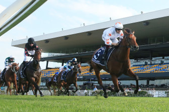
This year’s Golden Slipper has been postponed because wet weather made it unsafe.Credit:Getty Images
Chief steward Marc Van Gestel made the decision at 6.30am today following an inspection of the track after a few horses had worked on it. Rosehill had received almost 100mm of rain during the past few days, but it was the further 25mm on Saturday morning which made it unsafe to race.
According to the Bureau of Meteorology, parts of Sydney will be drenched by up to 250mm of rain as the day goes on.
Cafe submerged as torrential rain impacts Mid North Coast
The impact of flooding across NSW is being felt far and wide.
Yesterday afternoon, just after 2.30, Mid North Coast eatery Miss Nellie’s Cafe, in Kendall, posted on its Facebook: “Despite best efforts, the water is now going inside the cafe... thinking of my poor neighbours and their homes on River Street.”
Just under three hours later, the cafe was underwater:
Records broken on Mid North Coast as several flood warnings issued across state
A major flood warning is in place for parts of the Mid North Coast, with flood peaks on the Hastings River and Camden Haven river exceeding previous records.
The Bureau of Meteorology said “major flood peaks” have been observed, with further rises possible due to further rainfall being forecast this weekend.
Here are the flood warnings across NSW:
- Major flooding along the Hastings River on the Mid North Coast (at Kindee Bridge, Wauchope and Settlement Point) has exceeded the levels of a record flood in 2013. The peak at Kindee Bridge was 12.1 metres at about 11pm on Friday, with major flooding ongoing
- Major flooding is occurring along the Camden Haven River at Logans Crossing on the Mid North Coast, with a second peak of 9.3 metres observed at about 2am on Saturday. Major flooding is occurring at Laurieton, exceeding the 1978 record flood level
- Major flooding is occurring along the Nambucca River at Bowraville and Macksville. Further rainfall is forecast for the remainder of today into the weekend, with further rises possible.
- Moderate flooding is possible at North Richmond, Windsor and Putty Road, north-west of Sydney, on Saturday. The catchment is “saturated” after significant rainfall for the last week, with more rain expected
- Moderate flooding is possible along the Hawkesbury and Lower Nepean River. The Hawkesbury River at North Richmond is likely to exceed the minor flood level (3.8m) around midday on Saturday, with further rises possible
- The Hawkesbury River at Windsor is likely to reach the minor flood level (5.8m) on Saturday afternoon, with further rises possible
- Minor flooding is expected at Tuggerah Lake (at Long Jetty) and Wyong on the Central Coast
Share your extreme weather stories and photos
Is your town or suburb impacted by the flooding across NSW today? Get in touch:
‘Take extreme care’: Motorists warned of low visibility from heavy rain
Motorists in all suburbs of Sydney should take “extreme care” if they venture out on Saturday, with up to 200mm of rain expected to bucket down on parts of the city in the space of 24 hours.
In an alert issued early on Saturday morning, the Bureau of Meteorology said “reduced visibility in very heavy rain will make road conditions dangerous during Saturday”.
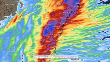
The latest model guidance on Saturday’s rainfall in and around Sydney. The heaviest falls could occur north and west of Sydney, targeting the Blue Mountains, Central Coast and Lake Burragorang / Warragamba Dam. This model (ACCESS-C) suggests some areas could see >200mm.Credit:Weatherzone
“Motorists are advised to take extreme care,” the bureau said.
Flooding and fallen trees have already closed some roads across the state, with a landslide recorded at Dorrigo in northern NSW. In Port Stephens, flooding from persistent rain has damaged Foreshore Drive.
For the latest road closures check the Live Traffic NSW website.
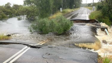
Flooding damages the road at Foreshore Drive in Port Stephens.Credit:Port Stephens Council
Up to 200mm of rain expected for Sydney with evacuations, flooding on Mid North Coast
Good morning and welcome to our live coverage of the wild weather in NSW today.
Here’s what’s happened so far:
- The State Emergency Service has issued evacuation orders for low-lying properties in the Kempsey CBD, Port Macquarie, Lower Macleay and parts of the Mid North Coast, as widespread and persistent rain moves south towards Sydney
- The forecast rainfall totals in Sydney today are between 150 and 200 millimetres in Penrith and Richmond, up to 150 millimetres in Parramatta, Liverpool and Campbelltown, and up to 120 millimetres in the city and at Bondi
- The rain is expected to impact a large area between Newcastle and Kiama
- The Bureau of Meteorology says there may be periods of “intense rainfall, potentially leading to life-threatening flash flooding”
And here’s what the rain radar looks like this morning:
We’ll bring you the latest as it happens.
Most Viewed in National
https://news.google.com/__i/rss/rd/articles/CBMiogFodHRwczovL3d3dy5zbWguY29tLmF1L25hdGlvbmFsL25zdy9uc3ctcmFpbi1saXZlLXVwZGF0ZXMtc2VzLWlzc3Vlcy1ldmFjdWF0aW9uLW9yZGVycy1mb3ItbWlkLW5vcnRoLWNvYXN0LWFzLXN0YXRlLWxhc2hlZC1ieS1leHRyZW1lLXdlYXRoZXItMjAyMTAzMTktcDU3Y2U4Lmh0bWzSAaIBaHR0cHM6Ly9hbXAuc21oLmNvbS5hdS9uYXRpb25hbC9uc3cvbnN3LXJhaW4tbGl2ZS11cGRhdGVzLXNlcy1pc3N1ZXMtZXZhY3VhdGlvbi1vcmRlcnMtZm9yLW1pZC1ub3J0aC1jb2FzdC1hcy1zdGF0ZS1sYXNoZWQtYnktZXh0cmVtZS13ZWF0aGVyLTIwMjEwMzE5LXA1N2NlOC5odG1s?oc=5
2021-03-19 22:01:15Z
52781443221396
Bagikan Berita Ini


0 Response to "NSW rain LIVE updates: SES issues evacuation orders for Mid North Coast as state lashed by extreme weather - The Sydney Morning Herald"
Post a Comment