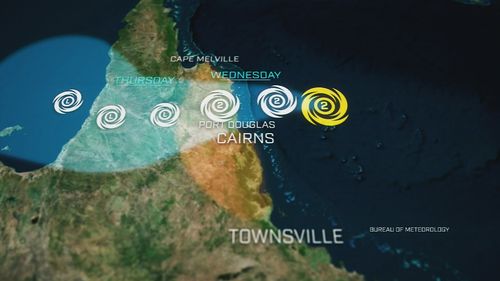
At 8.15am the cyclone was visible on the Bureau of Meteorology's radar about 120km east of Cairns, with the centre to the west of Bougainville Reef.
The storm weakened to category 1 last night but was expected to strengthen again before crossing the coast this afternoon, bringing "life-threatening" flash flooding and destructive winds of up to 140km/h to some parts.

At 9am, the warning zones spans Cape Melville to Cardwell including Cairns and Innisfail and inland to the Atherton Tablelands, Chillagoe and Palmerville.
"There are sustained winds near the centre of 85 kilometres per hour with wind gusts to 110 kilometres per hour," the bureau said in its update.
It warned wind gusts of up to 140 km/h may develop near and south of the track between Wujal Wujal and Innisfail, including Cairns, from this afternoon.
Currently at category 1 strength, the cyclone is forecast to cross the coast late this afternoon or evening between Hopevale and Cairns
Cairns Mayor Terry James told Today this morning the risk of the a tidal surge had lessened but powerful winds were still expected in the region.
"We will still get gusts, you know, potentially up to 140km/h and a lot of rain, that's what we are expecting at this stage.," he said.
Isolated six-hourly rainfall totals between 250 to 300 millimetres are likely between Cape Flattery and Port Douglas, where the December average is 214 millimetres. Some daily totals could hit 500 millimetres.
There are also concerns of flooding in areas close to beaches due to the high tide in some parts later today, the bureau warned.
"As the cyclone approaches the coast, a storm tide is expected between Cooktown and Lucinda on the high tides on Wednesday.
"Large waves may produce minor flooding along the foreshore. People living in areas likely to be affected by this flooding should take measures to protect their property as much as possible and be prepared to help their neighbours."

Emergency alerts were issued yesterday for Douglas Shire, where residents were urged to take shelter in the strongest part of the building they were in, and Wujal Wujal.
In Cairns, about 25,000 people in the red and orange flood zones were told to prepare to leave and plan to stay with friends or family on higher ground. Evacuation centres were also set up at the Edmonton Storm Tide Cyclone Shelter and Redlynch State College.
Senior meteorologist Laura Boekel said the warning areas could change and urged residents to stay up to date with the bureau's track map, which updates every three hours.
She said category 2 winds could typically bring down large trees and move large objects that had not been secured.
"It's important to note that gale-force winds are not just gusts of wind that happen occasionally," Boekel said.
"They can be consistent and sustained winds, so very strong winds occur at a consistent rate."

Authorities were preparing long before the storm hit. A pre-emptive disaster declaration was made yesterday for the area between Cape Melville and Townsville, as emergency response teams flew in from Brisbane.
The impending cyclone has also disrupted long-awaited holiday plans.
Several airlines cancelled and rescheduled flights even before Cairns Airport closed at 8pm yesterday.
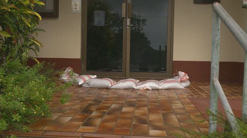
"Do not come to the airport because the airport terminals will physically be barricaded with sandbags," chief executive Richard Barker said.
"The runway itself will be available for emergency services but there are no scheduled flights."


Operators said the airport would stay closed today and promised an update at 6pm.
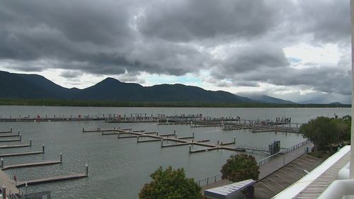
On the water, just one solitary boat was left in the Cairns marina, as owners fled upstream to shelter.
"They're all jammed in up the creek in up there so, there's never been this many boats in the river," boatie Rod McNeil said.
" … I'm fuelled, water, plenty of noodles, plenty of gas so I'm good to go."
Queensland Premier-in-waiting Steven Miles reassured residents the state was prepared.
"As you know, Queensland is the most disaster-affected state in Australia, our authorities are well prepared to support Queenslanders through whatever Tropical Cyclone Jasper throws at us," Miles said yesterday.
Some supermarket shelves in Cairns have been emptied ahead of the cyclone, as residents stock up.
https://news.google.com/rss/articles/CBMieWh0dHBzOi8vd3d3LjluZXdzLmNvbS5hdS9uYXRpb25hbC9jeWNsb25lLWphc3Blci11cGRhdGUtYm9tLXRyYWNrLW1hcC1sYW5kZmFsbC10b2RheS80NjkyNTgzZS01NmUxLTRmNDktODYyMC0wZGE5ODgwZDQ4ZjTSAQA?oc=5
2023-12-12 23:29:44Z
CBMieWh0dHBzOi8vd3d3LjluZXdzLmNvbS5hdS9uYXRpb25hbC9jeWNsb25lLWphc3Blci11cGRhdGUtYm9tLXRyYWNrLW1hcC1sYW5kZmFsbC10b2RheS80NjkyNTgzZS01NmUxLTRmNDktODYyMC0wZGE5ODgwZDQ4ZjTSAQA
Bagikan Berita Ini


0 Response to "Tropical cyclone closes in on coast as residents brace for a month's rain in six hours - 9News"
Post a Comment