Dangerous weather and “relentless” rain is expected to continue up until at least Tuesday as residents are being warned to brace for damaging winds, flash flooding, heavy rainfall, “abnormally” high tides and disappearing beaches.
A severe weather warning held overnight for a number of areas in NSW’s Northern Rivers mid-north coast regions, including the Tweed Coast and Byron Bay and experts say the rain bomb isn’t going any where any time soon.
RELATED: Byron Bay’s Main Beach washed away
Monday will be the “critical time” for NSW as the trough moves further south and saturated rivers rise even further and the SES prepares for the worst in the first major La Nina event of the summer.
By Tuesday, three day totals of 300-600 ml are predicted to fall across the region.
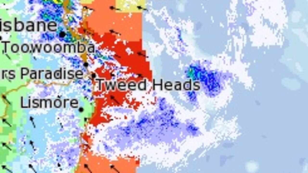
Authorities are urging caution and to prepare for local flooding as a trough deepens and moves away from southeast Queensland.
“The community should prepare for minor to major flooding so please check for warnings and updates over the coming days,” BOM meteorologist Jonathan How said.
“This is the most significant rainfall event since February and floods will pose a risk to many people.”
Overnight dozens of SES, RFS and Fire and Rescue crews were on standby as winds averaging 60-70 km/h and gusts exceeding 90 km/h were predicted along the coastal fringe north from the beachside town of Yamba overnight, and possibly extending south to about Crescent Head on the Mid North Coast Monday.
WHERE IS IT COMING FROM?
The storm is coming out of a trough over the Coral Sea which is deepening offshore of the southern Queensland coast. It is expected to form en masse overnight and into Monday as it makes its way down the Far North Coast, through the Mid North Coast on Tuesday and further south on Wednesday.
“This system is likely to bring significant rainfall, strong winds and large waves to the northern half of the coast until Tuesday,” warned the Bureau of Meteorology.
Streets in Coffs Harbour and Tumbulgum flooded over the weekend while four people were rescued from floodwaters in NSW on Saturday night.
HEAVY RAIN
A late night message from the Bureau of Meteorology predicted heavy rain “is expected to become severe again over the Northern Rivers from early Monday morning and parts of the Mid North Coast during the day.
“Rainfall rates could be locally enhanced in the far north with thunderstorms on Monday, leading to the possibility of very heavy rainfall and dangerous flash flooding.”
The rain is expected to fall until at least late Tuesday or early Wednesday in the region but the addition of thunderstorms could spell flash flooding on Wednesday.
Some areas on the Gold Coast and northern NSW border recorded more than 350mm of rain since Saturday. More than 400mm of rain fell in Numinbah, a rural locality on the Gold Coast.
HIGH TIDES SWEEP BEACHES, MORE TO COME
High tides have washed away the popular sandy Main Beach in Byron Bay as waves were seen crashing up against rocks, adjacent to a levelled footpath and road.
More of Australia’s beaches are under threat as damaging surf, with waves possibly exceeding 5 metres in the surf zone, were expected overnight from Yamba, then extending south to Port Macquarie during Monday and possibly leading to significant beach erosion.
The BOM also warned ”abnormally high tides” are possible along the coast north from about Ballina during Monday morning’s high tide, which may lead to more localised coastal inundation.
“The combination of Damaging Surf and Abnormally High Tides may enhance the risk of significant beach erosion north from about Ballina,” the BOM said.
Surf and swell conditions are expected to be hazardous on Monday for coastal activities such as rock fishing, boating, and swimming in the following areas.
Swimmers and surfers have been urged to “stay out of the water and avoid walking near surf-exposed areas” by the NSW Police Force, Marine Area Command.
A hazardous surf warning is in place Monday for the Byron Coast, Coffs Coast, Macquarie Coast and Hunter Coast.
FLOODING
A Flood watch is current for the Mid North Coast and Northern Rivers and flood warnings have been issued for the Tweed, Wilsons, Bellinger and Brunswick Rivers.
Locations which may be affected include Lismore, Grafton, Coffs Harbour, Port Macquarie, Sawtell and Dorrigo.
River flooding for the Mid North Coast and Northern Rivers is also expected with river levels to rise further from Monday and Tuesday.
High water levels due to spring tides are also forecast over the next few days, which adds to the risk of flooding in lower tidal areas.
Renewed minor to moderate flooding is possible along the Tweed River with the heavy rainfall forecast from overnight Sunday into Tuesday.
WHAT YOU CAN DO
The State Emergency Service advises has urged residents to move vehicles under cover or away from trees, to secure or put away loose items around your house, yard and balcony and to keep at least 8 metres away from fallen power lines or objects that may be energised, such as fences.
Residents are also warned not to drive or walk through flood water and to keep clear of creeks and storm drains.
“Be aware that run-off from rainfall in fire affected areas may behave differently and be more rapid. It may also contain debris such as ash, soil, trees and rocks,” the SES said.
*”After bushfires, heavy rain and the loss of foliage can make the ground soft and heavy, leading to a greater chance of landslides.
“Stay vigilant and monitor conditions. Note that the landscape may have changed following bushfires.
For emergency help in floods and storms, ring your local SES Unit on 132 500
Residents in affected areas are being urged to keep up to date with the weather on the Bureau of Meteorology’s website
https://news.google.com/__i/rss/rd/articles/CBMiuQFodHRwczovL3d3dy5uZXdzLmNvbS5hdS90ZWNobm9sb2d5L2Vudmlyb25tZW50L2xhLW5pbmEtYnVyZWF1LW9mLW1ldGVvcm9sb2d5LXdhcm5zLW5zdy1yZXNpZGVudHMtdG8tcHJlcGFyZS1mb3ItY3JpdGljYWwtd2Vlay1vZi13aWxkLXdlYXRoZXIvbmV3cy1zdG9yeS8zODhlMGJiYWRjMzg5ZGRkMWZiY2YwMjE0ZWNmMGIwZtIBuQFodHRwczovL2FtcC5uZXdzLmNvbS5hdS90ZWNobm9sb2d5L2Vudmlyb25tZW50L2xhLW5pbmEtYnVyZWF1LW9mLW1ldGVvcm9sb2d5LXdhcm5zLW5zdy1yZXNpZGVudHMtdG8tcHJlcGFyZS1mb3ItY3JpdGljYWwtd2Vlay1vZi13aWxkLXdlYXRoZXIvbmV3cy1zdG9yeS8zODhlMGJiYWRjMzg5ZGRkMWZiY2YwMjE0ZWNmMGIwZg?oc=5
2020-12-13 14:09:48Z
52781237678960
Bagikan Berita Ini


0 Response to "La Nina: Bureau of Meteorology warns NSW residents to prepare for critical week of wild weather - NEWS.com.au"
Post a Comment