House filmed floating down a river at Taree
An entire house has been seen floating down a river at Taree after heavy rains brought flooding to the region.
The home appears to still have fencing and concrete patio attached.
Watch the video below:
‘Very significant record-breaking event’: Up to 300mm of rain forecast for lower Blue Mountains
Sydney will get widespread rainfall of 100mm, with heavier falls of 200 to 300mm forecast for the lower Blue Mountains, during the “very significant record-breaking event” which brought major flooding to the Mid North Coast.
There is the potential for “very significant” flooding along the Hawkesbury and Nepean river this weekend, which is “the area of most concern”, with a flood warning also expected to be issued for the Georges River and Hunter River.
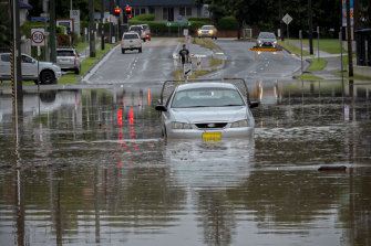
Flooding on Buller Street in Port Macquarie on Saturday.Credit:Rich Shaw
In a media update on Saturday, Justin Robinson – the national flood services manager for the Bureau of Meterology – said Warragamba Dam is expected to spill this afternoon. He said the last significant spill was in August 1990.
“This is a very dynamic, evolving flood situation,” Mr Robinson said.
Agata Imielska from the Bureau of Meteorology said there is the possibility for localised intense rainfall and damaging winds, and people should be aware of “dangerous conditions” that can change quite quickly.
“If you don’t need to travel, if you don’t need to head out today, this is the day to stay at home,” Ms Imielska said.
She said the Mid North Coast is not quite out of the woods yet, with some risk remaining, after receiving rainfalls that are “record-breaking for March, by 100 to 200mm above those March records”.
Rainfall of 405mm was recorded at Kendall, a “record heaviest rainfall we’ve seen”.
“It’s a very significant record-breaking event with the rainfall we have seen,” Ms Imielska said.
“Again, if you can stay home, stay safe, [it’s] really important to take that action.”
WATCH LIVE: Bureau of Meteorology update
The Bureau of Meteorology NSW is providing an update about the extreme weather conditions across the state. Watch the press conference here:
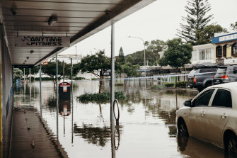
Photos: On the ground in Port Macquarie
By Ben Grubb
Photographer Matt Gilligan is on the ground in Port Macquarie, where he’s been documenting the deluge.
Trees are down on powerlines, sandbags are up outside cafes and shops, and floodwater is dispersed around car parks, town centres and front lawns.
‘A very scary time’: Drone photos show extent of flooding in Kempsey
By Ben Grubb
We’ve obtained some drone photography from Luke Jones, who is in Kempsey, a town on the Mid North Coast.
He says it’s been “a very scary time” for most residents due to the heavy rainfall across the region.
See the gallery below:
‘The worst flooding I can recall’: Port Macquarie CBD inundated with floodwaters
By Andrew Taylor
Port Macquarie residents experienced a brief reprieve from the rain on Saturday morning, with “a bit of blue sky” appearing between storm clouds.
But more rain is expected as Port Macquarie-Hastings councillor Geoff Hawkins described the disaster as unprecedented and “the worst flooding I can recall”.
“It’s affected more people and more seriously,” he said. It’s also affecting CBD areas - that’s unusual.”
Cr Hawkins said residents were coping “remarkably well considering we’ve had bushfires, we’ve had COVID, we had floods earlier”. But he added: “Eventually, [there’s] only so much you can take.”
Cr Hawkins said his home in Port Macquarie, located close to the Koala Hospital, was on higher ground and had not been affected by flooding.
Flooding in Port Macquarie on Saturday.Credit:Matt Gilligan
But he said: “It isn’t just the amount of rain we’ve had, it’s high winds. That has created problems for homes and businesses - not because of flooding, but getting storm damage.”
Fellow councillor Sharon Griffiths described the Hastings River as “bulging” from her home in Wauchope, about 20 minutes from Port Macquarie, where roads had been flooded and cut.
Floodwaters have also inundated the town of Kendall, 30 minutes south of Port Macquarie, with reports that part of a building housing Miss Nellie’s cafe was “floating away”.
The cafe’s owner, Janelle Nosworthy, said the damage was “even worse than we could have imagined - no words”.
“We are safe at home, but please think of my poor neighbours,” she said. “Their homes and families are suffering.”
Dozens of homes damaged in Sydney’s west
More than 30 homes have been damaged at Chester Hill in Sydney’s west as the city is hit by heavy rain.
Power and traffic around the area is affected. There is also minor flooding over roads across Sydney as the rain continues coming down.
Motorists are advised to slow down, take extra time, and stay home if you don’t need to go out. Do not drive through flooded roads.
Anyone who needs information on flood-affected areas in NSW can call the Public Information Inquiry Centre on 1800 227 228.
Authorities to provide update later today
By Ben Grubb
The NSW Police and Emergency Services Minister David Elliott and NSW State Emergency Service Commissioner Carlene York will provide an operational update on the storm and flooding events across the state at 3pm AEDT on Saturday.
We’re also expecting the Bureau Of Meteorology to hold a media conference at 12pm.
We’ll aim to bring you those press conferences as a live stream.
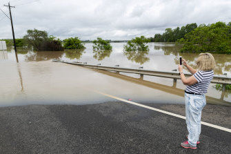
Rivers looking more like lakes in pictures of flooding
Here’s some more pictures and vision of the swollen rivers across the state.
The Parramatta River has swallowed a bike path, while the Macleay River near Kempsey and the Hastings River at Port Macquarie are looking more like lakes.
Meanwhile, birds are taking advantage of an instant wetland that’s popped up at Sydney’s Centennial Park.
Major flooding possible for north-west Sydney
Major flooding is possible for the Hawkesbury, Nepean and Colo Rivers north-west of Sydney on Saturday, with moderate flooding in other areas nearby.
In an alert on Saturday morning, the Bureau of Meteorology said major flooding is possible at North Richmond, Windsor and Sackville from late Saturday, which “may be similar to the February 2020 event”.
Flooding at Windsor in February 2020.Credit:Rhett Wyman
“Moderate flooding is possible along the Nepean River at Menangle, Wallacia and Penrith late Saturday into Sunday,” the Bureau said.
The Colo River at Putty Road is expected to reach minor flood level at about midday, with major flooding possible later.
“No river level observations are available for the Colo River at Putty Road,” the Bureau said.
The Nepean River at Menangle Bridge is likely to exceed 5.2 metres (the minor flood level) on Saturday afternoon, possibly rising to a moderate flood overnight.
Major flooding is possible along the Hawkesbury and Lower Nepean River, with the Nepean River likely to exceed 3.9 metres (the minor flood level) on Saturday evening.
The Hawkesbury River at North Richmond is expected to reach the minor flood level (3.8 metres) at about midday today, then continue rising. It could reach the moderate level (7.9 metres) on Saturday evening then rise further to become a major flood.
Major floods are also possible on the Hawkesbury at Windsor and Sackville, with a moderate flood possible at Lower Portland and Wisemans Ferry.
Moderate flooding is also possible at Wollombi Brook on Saturday afternoon, at Wollombi and Bulga.
Most Viewed in National
https://news.google.com/__i/rss/rd/articles/CBMiogFodHRwczovL3d3dy5zbWguY29tLmF1L25hdGlvbmFsL25zdy9uc3ctcmFpbi1saXZlLXVwZGF0ZXMtc2VzLWlzc3Vlcy1ldmFjdWF0aW9uLW9yZGVycy1mb3ItbWlkLW5vcnRoLWNvYXN0LWFzLXN0YXRlLWxhc2hlZC1ieS1leHRyZW1lLXdlYXRoZXItMjAyMTAzMTktcDU3Y2U4Lmh0bWzSAaIBaHR0cHM6Ly9hbXAuc21oLmNvbS5hdS9uYXRpb25hbC9uc3cvbnN3LXJhaW4tbGl2ZS11cGRhdGVzLXNlcy1pc3N1ZXMtZXZhY3VhdGlvbi1vcmRlcnMtZm9yLW1pZC1ub3J0aC1jb2FzdC1hcy1zdGF0ZS1sYXNoZWQtYnktZXh0cmVtZS13ZWF0aGVyLTIwMjEwMzE5LXA1N2NlOC5odG1s?oc=5
2021-03-20 01:57:50Z
52781443221396
Bagikan Berita Ini


0 Response to "NSW rain LIVE updates: Heavy rain causes major flooding, triggers evacuations in Mid North Coast, damages homes in Sydney’s west - The Sydney Morning Herald"
Post a Comment