Australia Day could see temperature records “challenged” and even broken as more punishing heat washes across the nation.
In some areas almost 50C may be on the cards.
Sydney, Brisbane and Perth could have temperatures into the mid-thirties. That’ll be good for barbecues but don’t leave them too late in the day on the east coast as rain is due on Australia Day afternoon.
Indeed in the country’s north, barbecue plans could be entirely washed away by a combination of the monsoon and a cyclone.
Cyclone Kirrily is forecast to be on a direct course for Townsville bringing dangerous winds, possible flooding and life threatening conditions.
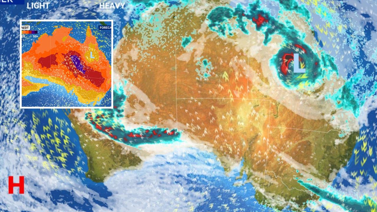
Large areas of high pressure are squatting over the Tasman Sea close to Australia’s south east and off the south Western Australia coast while low pressure dominates in the country’s north.
Queensland a ‘state of extremes’
“Queensland could become a state of extremes for Australia Day,” Sky News Weather meteorologist Rob Sharpe told news.com.au.
“Tropical cyclone Kirrily is very likely to strike the Queensland north east coast this week while record challenging temperatures will continue in the southwest of the state.
“Queensland’s hottest temperature on record is 49.5C, recorded at Birdsville. The outback town should get close to that mark on Thursday or Friday.”
Currently around 800km off shore, the prediction is for what is now called tropical low “05U” to reach cyclone strength later on Tuesday.
As Cyclone Kirrily it’s expected to strike the coast around Townsville as a category 3 cyclone late on Thursday. However tropical cyclones are notorious for changing direction with forecasts like to firm up as the week progresses.
The Bureau of Meteorology has said gales with gusts of up to 120 km/h may develop about the Whitsunday Islands from as early as Wednesday morning and extend to areas between Townsville and St Lawrence later that day. Winds of up to 150 km/h could be experienced between Cardwell and Laguna Quays overnight Wednesday or on Thursday.
Heavy rainfall and flash flooding which could be “dangerous and life threatening” could develop close to the system’s path on Thursday.
On Australia Day itself the storm will push further inland with the system potentially bringing heavy rain to the state’s south east over the weekend.
Townsville is looking at anything from 20 to 120mm of rain on Thursday and up to 35mm on Australia Day.
Brisbane could see some showers of Wednesday and a high of 32C. Australia Day weekend could be a washout where with a possible 60mm of rain coming down on Saturday.
Heatwave for NSW
New South Wales will see a heatwave of low-to-severe intensity with the epicentre being the central east of the state.
Towns including Cobar and Walgett are forecast to have consecutive days in the low forties.
“Hot weather will come in from Wednesday to Friday for much of NSW, ahead of a cool southerly change that will run through Sydney on Friday,” said Mr Sharpe.
The run up to Australia Day in Sydney will see glorious blue skies and a high of 30C on Wednesday, ramping up to 35C on Thursday.
Australia Day could be partly cloudy with a 34C high but temperatures will drop in the late afternoon and evening as a storm rolls through with rain.
That will lead to a cooler weekend in the mid-twenties with some cloud.
Northern parts of the state, like Ballina, should remain dry and warm on Australia Day but, like south east Queensland, Saturday could be very with up to 40mm of rain.
Newcastle is forecast to record up to 10mm of rain on Friday, again as a late afternoon change rolls through.
The state’s south should be cooler with Bega on 24C for Friday January 26 with rain.
The hottest day of the week in Canberra is looking like be Thursday with 34C – up from Wednesday’s 31C. Friday will see a 28C high in the capital with some showers in the morning.
The weekend is expected to be dry and warm in the capital just pushing into the thirties.
Cooler in the south
Further south, there will be some showers for western Tasmania and for southern and eastern Victoria.
Melbourne could get a few drops on Thursday as the mercury peaks at 16C. Australia Day is expected to get up to 23C with little in the way of rain and then similar for the weekend.
Wednesday in Hobart will crank up to 28C but then temperatures will gradually come down until a projected high of 21C on Australia Day with perhaps a passing shower or two in the morning.
It’s will be similar for Saturday and then 25C on Sunday.
Tuesday will be sweltering in Adelaide with a 41C high but then either will be a 10 degree drop to Wednesday’s 31C.
By Friday, the South Australian capital will top out a mere 24C but it should remain dry. By Sunday the mercury could be back up to almost 30C.
A hot but not scorching Australia Day in Perth with a maximum of 33C, up from a midweek 29C high. The Australia Day weekend will remain warm but temperatures could go down to 28C.
More Coverage
“By Australia Day, the monsoon low that spent a week over the Territory, will be soaking parts of northern and central WA with its first substantial rain for the wet season, helping to drop temperatures after the extreme heat currently being experienced there,” said Mr Sharpe.
That means the state’s north could actually be cooler then Perth for once with Friday in Karratha reaching 31C. In the south, Albany is looking at 21C.
A soggy January 26 in Darwin with up to 25mm, or rain and a 31C high. Alice Springs could see multiple days in the forties this week with 24C on Wednesday and Thursday but a slightly cooler 38C for Friday.
https://news.google.com/rss/articles/CBMinwFodHRwczovL3d3dy5uZXdzLmNvbS5hdS9uYXRpb25hbC93ZWF0aGVyL2F1c3RyYWxpYS1kYXktd2VhdGhlci1oZWF0d2F2ZS1yZWNvcmQtY2hhbGxlbmdpbmctaGVhdC1hbmQtY3ljbG9uZS1raXJyaWx5L25ld3Mtc3RvcnkvZDYxZjAxZDEzYzU1NWIzOTFmN2U0ODdhMTQ2ZjBhZjfSAQA?oc=5
2024-01-22 19:52:30Z
CBMinwFodHRwczovL3d3dy5uZXdzLmNvbS5hdS9uYXRpb25hbC93ZWF0aGVyL2F1c3RyYWxpYS1kYXktd2VhdGhlci1oZWF0d2F2ZS1yZWNvcmQtY2hhbGxlbmdpbmctaGVhdC1hbmQtY3ljbG9uZS1raXJyaWx5L25ld3Mtc3RvcnkvZDYxZjAxZDEzYzU1NWIzOTFmN2U0ODdhMTQ2ZjBhZjfSAQA
Bagikan Berita Ini


0 Response to "BBQs could be off: Grim Aus Day forecast - news.com.au"
Post a Comment